More information about project monitoring can be found in the project reports (subtask 9)
Studie Bazels GGG
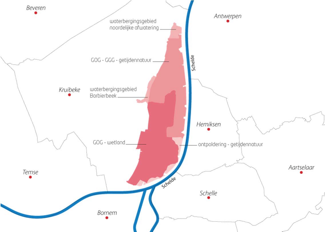 In 1994 the Flemish government decided that the polders of Kruibeke, Bazel and Rupelmonde, which were identified as GOG in the original Sigmaplan (1976), would now function as a nature reserve of 150 hectares of meadow bird area and 300 hectares of tidal marshes. Although the work on the entire area is not yet finished, part of the Basel polder can be already opened. This part of the GOG was, just like the whole polder of Kruibeke, used for the development of estuarine nature through the GGG concept. A lock construction with a combined inlet and outlet above each other causes a reduced tide, but retains a springtide - neaptide variation. The Basel polder will merge meadow bird area and estuarine nature into one another. It will therefore not be classic salt marsh with reeds and willow thickets. Here the aim is to graze the salt marsh, so that it would be attractive for grassland birds. This has particular implications for the allowed tide in the GOG. The tide must indeed promote the development of wet grasslands, but should not be an obstacle for grazing or mowing. It is therefore essential to properly assess the amount of water that enters the flooded area during the opening of the floodgates.
Bergenmeersen

One of the Sigma project areas from the cluster "Kalkense Meersen" Bergenmeersen is located in Wichelen. In March 2012 this area started evolving from GOG to GOG-GGG, a change which was completed in April 2013. The aim was to set a most favorable tide to reach the target for the GGG: a functional intertidal area which contributes to the ecosystem functioning of the Scheldt. The area should be managed in a sustainable way, the safety function as GOG should never be compromised and no discomfort to local residents may arise. The latter mainly refers to the possible arrival of biting midges to the area, which may cause nuisance to local residents. All this clearly imposes several conditions for the tide.
Studie Burchtse Weel
 Burchtse Weel is a project located between the left bank of the city of Antwerp and Burcht. This former "weel", which was formed in the 19th century by a dike breach, was a recreation area before the construction works began. The salt marshes of the Lower Scheldt are protected habitats. Construction in the Scheldt may therefore have a negative impact on these protected habitats, and compensation is necessary with the loss of habitats. Burchtse Weel fits within those commitments and aims to create estuarine nature (salt marshes) as a mitigation measure for temporary losses in the construction of a tunnel under the Scheldt by BAM. However, the meaning of the term estuarine nature may vary. Since with tunnel work primarily a disturbance of the marshes will occur, it could probably be sufficient to temporarily create marsh habitats for BAM as a mitigation measure. The weel is connected with the Scheldt through a system of locks, allowing tide in the area. The lock construction at Burchtse Weel consists of one low-lying lock that is used for both inlet and outlet and is different from the lock system of GGG. The locks from Burchtse Weel to the Scheldt were opened in January 2011. Flood height, duration and frequency varies greatly compared to a GGG. Different flooding frequencies have led to different kinds of vegetation, sedimentation and erosion patterns with respect to a GGG. Due to technical problems with an old lock and sewers, the locks were closed in 2011. During this period, the large quantity of sludge that was disposed of on that short period, settled. Initially, this was followed by basic monitoring of the area. With the closing of the locks, monitoring is minimized to measure elevation changes and vegetation recordings only. Then, the Weel was reopened in March 2013 and the sedimentation started again. A limited monitoring program was set up to measure the sedimentation problem. The reopening of the area does not lead to the development of a valuable short-term estuarine nature and even the long-term success is still doubtful.
Lippenbroek
 In Hamme, the project Lippenbroek is explicitly following the GOG-GGG-principle since March 2006, as part of research monitoring in OMES. The project focuses on how to develop sustainable ecological structures and functions in GOG-GGG's equivalent to those outside the dikes tidal marshes. The Lippenbroek survey has been running for eight years. Hydrodynamics is a crucial indicator as hydrology is the main driving force behind physical, biological and chemical processes in intertidal areas.
The hydrological regime in GOG-GGG differs slightly from outer dike situations, and may have a potential impact on determining the structures and ecosystem functions in the study area. A tidal regime with clear spring-neap tide variation is effectively observed, but with a modified flood duration and height. Intensive monitoring examines the impact on the overall ecological functioning, i.e. vegetation, plankton and benthos, fish and birds, water and soil quality. This has led to an ambitious spatio-temporal monitoring scheme, wherein sedimentation is given special attention. Sedimentation is not only important from an ecological point of view, it is also crucial in terms of the safety aspect. A GOG-GGG is no longer directly dependent on the altitude of the ground, but depends mainly on the mass of water flowing into the area through the locks, which makes that existing laws no longer apply.
The negative feedback mechanism, where high salt marshes are less frequent flooded and do not have a pronounced increase, does not fully apply in GGG's. Sedimentation will thus be given special attention.
 OMES is a project funded by the Flemish Government