History of OMES
Since 1995, OMES has been monitoring the development of the Scheldt estuary. The research programme assesses the environmental effects of the Sigma Plan, dredging activities and harbour expansion, providing valuable knowledge for the sustainable management of the Sea Scheldt.
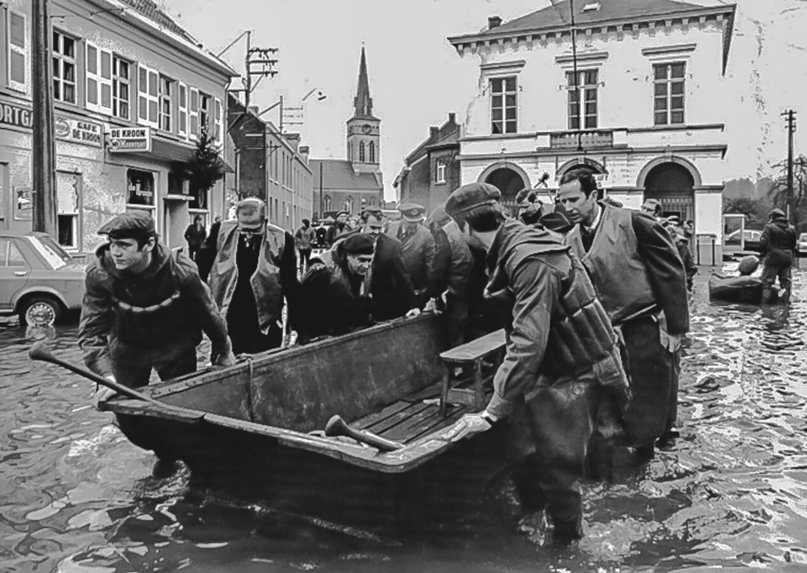
1976: the origin of the Sigma Plan
OMES was established to assess the environmental effects of the Sigma Plan. The storm surge of 3 January 1976 and the subsequent floods led to the implementation of this extensive plan, which aims to protect the entire Sea Scheldt basin against flooding. The Sigma Plan pursues the same level of flood protection as the Delta Plan for the Western Scheldt. This means that the design storm tide has a probability of occurring once every 100 years, resulting in a water level of 9.05 m TAW in Antwerp.
1994: an emergency and urgent action programme
Following another storm in 1994, which resulted in the highest water levels ever recorded in the Sea Scheldt, an emergency and urgent action programme was approved. Its implementation had to fit within an integrated vision for watercourse management. This led to a General Environmental Impact Study for the Sigma Plan and, subsequently, to the Environmental Impact Research for the Sigma Plan, known as OMES.
1995: the start of the OMES project
The OMES project aimed to update and significantly expand the biogeochemical knowledge of the Sea Scheldt. An extensive monitoring programme was launched: “Research into the effects of the Sigma Plan, dredging activities and harbour expansion in the Sea Scheldt on the environment”, abbreviated as OMES. However, an estuary is a highly complex system influenced by various (human) factors. Monitoring must therefore be carried out across multiple research domains. In this new approach (where OMES became part of MONEOS), in which safety, accessibility and ecological integrity are addressed together, a thorough understanding of the Scheldt estuarine ecosystem is essential. OMES has become an important instrument for scientific research in the estuary. Monitoring only becomes truly valuable when measurements are carried out systematically over a long period. Only then can long-term effects and trends be distinguished from short-term variations. It is therefore essential to create a dataset without major gaps. OMES can look back on a large and consistent dataset: since December 1995, sampling has been carried out monthly at fixed locations according to a fixed schedule. With only a few exceptions (due to logistical difficulties involving one of the monitoring vessels), there have never been interruptions in the sampling pattern.
2008: the introduction of MONEOS
In the spring of 2008, MONEOS was introduced: a programme for integrated monitoring of the Scheldt estuary in the Netherlands and Flanders. The MONEOS programme describes the monitoring required to document developments in the Scheldt and identify cause-and-effect relationships. This is essential for scientifically sound estuary management. The programme covers various aspects of the Scheldt ecosystem, ranging from hydro- and morphodynamics, habitat diversity, physicochemistry, ecological functioning and species diversity. Within this framework, OMES is responsible for an important part of the physicochemical and ecological monitoring of the Sea Scheldt. In 2009, the OMES programme was aligned with the recommendations of MONEOS. Since then, the estuarine OMES monitoring campaigns have consisted of three survey days, held on Monday, Tuesday and Wednesday.
1995–2009: the development of OMES
During the first three phases of OMES (1995–2003), the role of the intertidal zone in the functioning of the ecosystem was modelled. During this period, chemical, biological and ecological data were collected. The multidisciplinary knowledge of the Scheldt estuary made it possible to identify potential alternatives to the Sigma dikes and to develop a suitable proposal for estuary water management.
The fourth phase of OMES started in 2006 and continued the monitoring of the ecosystem components from the third phase. Particular attention was given to the potential role of controlled flood areas as a flood protection strategy and their impact on the estuarine environment.
A fifth phase continues the monitoring of the Scheldt, but is now incorporated into the new MONEOS monitoring programme within O&M, a collaboration between the Flemish and Dutch governments.
More information about OMES within MONEOS.
Phase 1: 1995–1998
- Biogeochemical cycles of C, N and the water balance. details
- Denitrification in intertidal sediments and water quality parameters. details
- Ecology of macrozoobenthos in the Sea Scheldt. details
- Ecology of fish populations in the Sea Scheldt. details
- Ecological modelling of the Sea Scheldt estuary and the study of biogeochemistry in the rhizosphere. details
- Flora and vegetation, avifauna, benthos and water quality parameters. details
- Geomorphology and logistical support. details
- Hydrodynamics. details
- Characterisation of organic matter and plankton in the Sea Scheldt. details
- Pedological characterisation of salt marshes and alluvial areas. details
- Sediment transport and sedimentation processes in the Scheldt between Zandvliet and Ghent. details
- Study of microplankton and the microbial loop in the Sea Scheldt. details
- Vegetation ecology of alluvial areas, salt marsh vegetation and flora. details
- Water balance. details
- Water quantity and logistical support. details
Phase 2: Integration, 1999
The OMES project initially consisted of a number of sub-projects, each focusing on a specific aspect of the estuarine ecosystem. Knowledge of the various processes within the biogeochemical cycles of carbon and nitrogen, the role of vegetation and benthos, pedology and sedimentology, among others, increased significantly. However, what was still lacking was an integrated view of all these individual aspects. A first step towards this integration was to gain a comprehensive understanding of water quality as essential background information. To achieve this, a compilation of all suitable datasets was prepared. This was complemented by the results from a data probe that had been recording water quality almost continuously near Kruibeke since 1996.
Phase 3: Research into the effects of the Sigma Plan, dredging activities and harbour expansion in the Sea Scheldt on the environment, 2002–2003
- Study of the baseline water quality in the Flemish section of the Scheldt estuary. details
- Study of the effects of water quality and tides on flood control areas in the Flemish section of the Scheldt estuary using two mesocosm setups. details
- Study of the carbon cycle in the Flemish section of the Scheldt estuary. details
- Study of primary production in the Flemish section of the Scheldt estuary. details
- Study of sedimentology in the Flemish section of the Scheldt estuary. details
- Study of lateral loading in the Flemish section of the Scheldt estuary. details
- Study of phytoplankton in the Flemish section of the Scheldt estuary. details
- Study of zooplankton in the Flemish section of the Scheldt estuary. details
Phase 4: Research into the effects of the Sigma Plan, dredging activities and harbour expansion in the Sea Scheldt on the environment, 2004–2007 + extension until 2009
- Baseline water quality in the Flemish section of the Scheldt estuary. details
- The carbon cycle in the Flemish section of the Scheldt estuary. details
- Primary production in the Flemish section of the Scheldt estuary. details
- Sedimentology in the Flemish section of the Scheldt estuary. details
- Phytoplankton in the Flemish section of the Scheldt estuary. details
- Zooplankton in the Flemish section of the Scheldt estuary. details
- Upgrade of the OMES database containing data from the Flemish section of the Scheldt estuary. details
- Study of vegetation under specific tidal conditions in the Flemish section of the Scheldt estuary using two mesocosm setups and the Lippenbroek study area.
Phase 5 in MONEOS, 2009–...
- Baseline water quality in the Flemish section of the Scheldt estuary. details
- The carbon cycle in the Flemish section of the Scheldt estuary. details
- Primary production in the Flemish section of the Scheldt estuary. details
- Sedimentology in the Flemish section of the Scheldt estuary. details
- Phytoplankton in the Flemish section of the Scheldt estuary. details
- Zooplankton in the Flemish section of the Scheldt estuary. details
- Upgrade of the OMES database containing data from the Flemish section of the Scheldt estuary. details
- Study of vegetation under specific tidal conditions in the Flemish section of the Scheldt estuary using two mesocosm setups and the Lippenbroek study area.
How does OMES work?
What exactly do we measure? Why do we monitor the Sea Scheldt? Discover the answers to the most frequently asked questions.
Still have questions?
Contact us.
Do you have another question or comment? Get in touch with us and we'll be happy to help you as soon as possible.